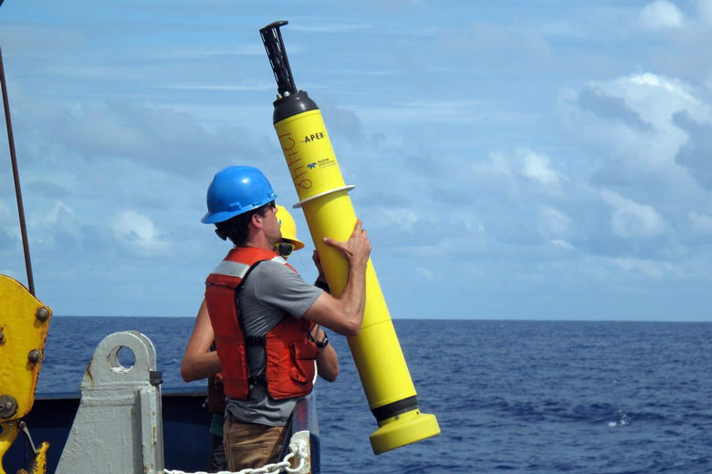
When the Maine Maritime Academy training ship State of Maine sailed from Castine May 8 for the start of the annual summer cruise, she carried 202 students, 25 faculty members, and a crew of 20 professional mariners. She also carried a unusual cargo: six high-tech drifter buoys to be launched along her cruise track through the Atlantic for the National Oceanic and Atmospheric Administration’s global Argo weather research project.
NOAA describes Argo as an international program to collect information from the sea using floating buoys that drift freely with the ocean currents and move up and down in the water column at regular intervals, measuring water temperature and salinity between the surface and a depth of 2,000 meters (about 6,600 feet.) Data from these floats—transmitted by satellite—are incorporated into weather forecasting models worldwide.
The day before the training ship sailed from Castine, Dr. Pelle Robbins, a physical oceanography research specialist at Cape Cod’s Woods Hole Oceanographic Institution (WHOI), delivered a half-dozen of the drifters to the MMA waterfront, each packed in a heavy cardboard box, and explained their use and how they should be deployed to a group including the State of Maine’s master, Capt. Gordon MacArthur, and Dr. Kerry Whittaker, assistant professor of coastal and marine environmental science in the academy’s ocean studies department.
“We have targeted the deployment of these floats for regions important for the formation and growth of hurricanes.”
The event marked a milestone both for Argo and MMA. Robbins said the program depends almost entirely on commercial ships and deep-sea fishing vessels to distribute its drifters throughout the world’s oceans. The venture with Maine Maritime Academy is the first time in its 25-year history that the Argo program has partnered with a state maritime academy to launch drifters from a training ship.
The choice of MMA was somewhat fortuitous.
“We try to maintain a fleet of 4,000,” Robbins said. “Currently, there’s a little bit of a thinning in the middle of the Atlantic.”
The middle of the Atlantic is exactly where the State of Maine will be as it travels to Spain. Besides the convenient cruise track, there was also an existing link between MMA and Woods Hole.
Before coming to Castine, Whittiker was an assistant professor of oceanography at the Woods Hole-based Sea Education Association, an experiential education program that takes college students to sea for a semester of scientific research aboard a pair of purpose-built sailing vessels. A WHOI colleague of Robbins with a connection to SEA contacted Whittaker who put her in touch with MacArthur.
“It’s really because of him” that the Argo-MMA connection came to fruition, Whittaker said.
She anticipates that the product of that connection will offer several educational opportunities to MMA students.
Midshipmen aboard the training ship will have the practical experience of deploying the ARGO drifters while at sea. That process should be relatively easy, Robbins said, because the drifters are encased in special cardboard containers with bottoms that essentially dissolve in the water. After the crew hoists the container back on board the training ship the drifter floats free and begins its work.
Whittaker plans to use data from the drifters in MMA’s ocean studies program, which offers both advanced courses for students majoring in that discipline and an introductory course for non-ocean studies majors. Groups of students, some of whom may well have been on the training cruise, might “adopt” individual buoys, she said, and trace their journey through the sea and track the data they transmit. She also hopes to establish an ocean studies seminar each semester and, perhaps, get Robbins back to MMA for a final presentation regarding the ARGO program.
“It’s really exciting,” Whittaker said.
When Robbins prepared the drifters for loading onto the ship in Castine, he said they were set in a “pressure activation mode” in which they “wake up” at 10-minute intervals and measure the pressure in the environment. “If it’s atmospheric pressure, they go back to sleep,” Robbins said. But, if the pressure is more than five times greater than normal atmospheric pressure at sea level, “that is a signal they are in the ocean and they commence their mission,” to measure ocean temperature and, when they periodically rise to the surface, transmit that data via satellite through channels that feed into weather forecasts.
“We have targeted the deployment of these floats for geographic regions important for the formation and growth of hurricanes,” Robbins said. “Our initial hope was for these new floats to be in place for the 2024 hurricane season and we are still on track for that goal.”


